Every time I’ve come close to dying. It’s involved a mountain, a steep slope and a somewhat reckless human. Uh, me, my name is Josh Cripps and I’ve had the unbelievable fortune to travel the world as a landscape photographer for most of the past decade. And in my years of adventuring around the planet, I’ve slid down IC shoots in New Zealand, tumbled off sandstone ramps in Utah, and been caught in rock slides in Chile. But nowhere have I had more close calls with gravity then on the granite mountain sides of my home range, the Sierra Nevada. So perhaps it shouldn’t surprise you. When I start this story here, perched at the top of what I would later come to call Satan’s crack. Do they get a giant shock stone there? John dropped there. Can’t tell how wide it is. It just looks at death and destruction. The whole way down. I had just scrambled up a thousand feet of talus to find a way over an unnamed pass in Kings Canyon, national park only to be confronted by this death trap way. I’m going down that with a bag on. So there, I was wondering how the hell I was going to get down that shoot without killing myself in the process, but in order for you to understand exactly how I ended up in that particular spot, I need to back up a little bit to the summer of 2017.
Wait, wait, there y’all must grant small for another mentor in place out Cal paradise.
Sergeant Kearsarge is well-known in the world of Sierra hiker, dumb, not just because of its spectacular scenic beauty, but also because it’s just about the easiest way to get over the Sierra crest to access the true wilderness of the Sierra back country. And on that particular trip, as I stood at top of the nearly 12,000 foot high Kearsarge pass gazing into King’s Canyon, I resolved to do something I rarely do all backpacking climb, a mountain or rather a small mountain, or rather this small mountain, the cutest and most pettiest of the Kearsarge pinnacles. After setting up camp near the largest of the Kearsarge lakes, I followed a meandering Creek uphill to the base of the pinnacle
Mosey up down there.
See what’s on the other side. And after
Some fun fourth class scrambling there, I was one single move below the summit.
I get to the very top, which is literally just three feet above me. Cause it’s kind of an awkward move right here over this hang and block with some ridiculous exposure. It’s probably not a hard move, but if you went down, man, you know, down Alex
Honnold, I am not, but as a wonderful consolation prize, I’ve found a granite ledge, some 50 feet below, which offered a sensational view West into the back country of Kings.
Dude who loves maps. And as I stood on that ledge, learning the names of the mighty Sierra peaks in front of me, one particular place on the map, drew my attention, the gardener basin, it was awfully remote, almost exclusively above treeline and surrounded by peaks with no trail leading to it. And no obviously easy way to get there. Now that looked interesting. And in that moment I resolved to visit the Gardner basin as soon as I could, but first I still had to climb down from that pinnacle and try not to get too cold overnight. I’m just a little bit chagrined to admit that I’ve forgotten to bring pants well this year trip, after that overnight trip time leashed by in a flurry of adventures. And before I knew it, summer 2018 had arrived and my backpacking legs were getting In late July long spell of thunderstorm activity was forecasted to hit the Sierra. And since that’s my favorite kind of weather to backpack in,
If you listen closely, you just might hear the peels. Thunderclaps often a distance that’s cast for rejoicing because incredible conditions for photography
That meant it was finally time to see what the Gardner basin was all about. Would it live up to my hopes and dreams of a glorious back country? Shangri-La would there be any good compositions or light for photography? Would I meet the woman of my dreams on her own solo backpacking adventure, or would it all be one big turd vest? There was only one way to know for sure. And that was to strap a 25 pound pack to my back, loaded up with another 10 pounds of camera gear and beat feet into the mountains. Having had the winter and spring to pour over my beloved Topo maps. I knew the exact route I was going to take into Gardner basin, starting from the onion Valley trail head. I’d hike up to the golden trout lakes. And from there head West cross-country over dragon pass and down to dragon Lake from there, I’d find my way into the Rae lakes basin, then hike over 60 lakes pass before turning South to navigate. Get another off-trail pass to finally reach Gardiner basin. That route would be about 13 and a half miles with 6,000 feet of elevation gain over multiple cross-country passes. It almost seemed too easy.
It is one hot dry dust is slow.
The route climbed, steeply up a Sandy trail to the beautiful golden trout lakes where I was treated to a particularly stunning sight
Carpets of superstar.
And here I’d like to take a little bit of a detour for a moment by now. You are surely wondering why I’m speaking with that drawl every time you see me in the field,
Well, either most grants, there is nothing quite like the clarity of mind that descends upon you. When you take that first step on a high Sierra trail.
Well, it’s a bit of a long story. So for now suffice it to say whenever that particular hat goes on my head, the accent come
Out of my mouth anyway, not took it about three and a half miles to walk, maybe another 1300 feet up to dragon pass. And it’s clouded up precipitously, which makes me a little bit worried that the Cumulus clouds AskPat earlier over the crest, maybe fixing to drop some range. So I better get a move on.
I continued hiking uphill until I reached the highest of the golden trout lakes where I could finally see my objective now.
Yeah. A little naggy is the pass that I’m trying to get over
Little. Did I realize that was not dragon pass at all, but rather the after mentioned
Satan’s crack, my guess is going to be one hour of travel to get about how to know it’s like half mile in your distance and 800 feet up. Oh boy, here we go.
By happily meandered up the rock and scree until I stood on that three foot wide press
At the top of the shoot. Well friends, I got to say that was an awful lot of hard work who this law was since coming back out, made it to the past and made it to Kings Canyon. So looking down this incredibly steep gully, so go down there at dragon Lake. That’s that first Lake that’s where I played the campsite and beyond that is Rae lakes basin. So how did the scout a little bit make sure these two precipitous drop-offs I can see directly down the Scully or not actually death falls and we’ll go from there.
I took off my pack and gingerly ease myself into the shoot to scout a path down. In this case, it was immediately obvious that this shoot was not a viable way down the mountain, but rather a death trap waiting to happen. I felt the screen sliding under my shoes and knew that if I didn’t get out of there soon, I never would scrambling at the rotten walls and peeling away layer. After layer of rock, I frantically pulled myself out of the shoot and set panting at the top, my heart pounding in my chest
All day long. There’s no way I’m going down that with a bag on it. Well, at this point, I, I meant to feeling a little bit bamboozled, I suppose it’s possible that I misread the Topo map and the two actual passes around that corner. But I do not believe so now I have to go back down in any case, cause they were sure, Hey, no way I’m going down. That gully proposition descent, I am excited about. Nevertheless I’m without option at the moment
Since dragon pass was not marked on my Topo map, I had assumed it would be the lowest point on the Ridge. But since that clearly wasn’t the case. I now had to rely on my own route finding skills to uncover a safe way up and over the Ridge
Came down, skirt that little rib and there’s definitely no, no pass over here then I thought, but it looks like there may be a way up to some of these rocks.
One thing I’ve discovered in my Sierra ramblings is that when you see a bunch of jumbled boulders, there’s almost always a way you can wriggle through them. I picked a line in the rocks above me and began to climb. Just to give you a little,
A bit of a, but not D of the type of tear rain we’re dealing with here, going across country, just rocks, rocks, and rocks up and up and up. We go,
I mean, it was going great for a while until it wasn’t. I had been scrambling of third and fourth class terrain challenging, but not impossible with a heavy pack on, but then I reached an impasse, a low fifth class, move up a whale shaped slap, and remember Alex Honnold I am not. So I could either down climb and look for yet another route over the Ridge, or I could hang myself out to dry on this slab. But since down climbing fourth class terrain with a heavy pack is heinous and sketchy. I decided to go up and with a graceful climbing technique, you could only describe as rock humping. I spread eagled myself on that slab and inched upward until I found solid handholds in a series of easy boulders. That to my great delight led to the summit Ridge.
Well, Holy, snacks combined race. I just want to say after that with a right whale penis, because my heart was pounding, pounding, pounding, pounding, going up dead. Anyway, it’s pretty frigging amazing up here. I got to say, now that I’m here, the views are just spectacular in every single direction. And when I got to the top here, I let out a whoop of trial and you know what came squirreling around the corner? A couple of big horn sheep. First time I seen him here in this year, pretty cool to be that close man, the fidelity with which they just ran down the spine over here and then down a gully was incredible. Now, thankfully I do believe it’s going to be possible to get down this Northwest side of the gully, like goodness, because just going back down to the Lake boy, that would be a hell of a moral defeat.
Great joy. I followed those sheepies to a Sandy gully where I partook in one of my favorite Sierra activities, a 1500 foot boot ski down the screen to the bottom of the gully.
Now that doesn’t seem dangerous at all. Doesn’t
Praise Jesus.
I made it to dragon Lake. I we’ll find like it is from
In the Lake. Not only was there a sensational view of Mount Cotter and Clarence King, but also a perfect look back into the sphincter clenching shoot. I initially thought was dragon pass. I allowed myself a retroactive shiver then went off to photograph the sunset over the sublime Ray lakes basin. Now I’ve heard
We had many, a town that the Ray lakes basin here in Kings Canyon is one of the most beautiful places in the Sierra. And I’ll tell you what, in this moment I would be hard pressed to disagree with that.
NOLA rewarding day chock full of stunning scenery, hard work, and only a few heart pounding moments thrown in for good measure.
After a near sleepless night caused
Perhaps by too much lingering adrenaline in my system, I woke the next day to piercingly blue skies in surprisingly warm temperatures.
Now it was hot. Last on downright hot.
As I packed up camp, the heat continued to build and given that it was barely 9:00 AM when the first puffy moisture Laden clouds of the day appeared,
Hopefully we’re going to be seeing loss of these gas today, Cumulus clouds, thunderstorms.
And so I made quick work of that mornings. Hiking first, I’ve got to drop down into
Great lakes. Check that out back gun with Cruz, little 35 minutes drove
All the time. The thunderclouds continued to stack up an hour later. By the time I had hiked up in over 60 lakes, past the skies word, dark and brooding. And while the hiking so far had not been particularly difficult little did I realize I’d soon face a challenge of a different nature? My initial trip plan called for me to stay that night in 60 lakes basin, but the weather intervened in a big way,
Little change plans. I really came out here to photograph the Gardner basin and thunderstorms, and it’s just over there about a mile and a half maybe thousand vertical feet. And since there’s no guarantee of thunderstorms tomorrow, that means today is the only option. So kind of going against my better judgment here to walk towards the storm. But, uh, that’s what you do for photography.
And if that isn’t a metaphor for life, I don’t know what it is. Sometimes you gotta walk toward the storm Upon reaching the saddle. I was shocked to see what lay on the other side,
Starbucks now just kidding. There’s absolutely nothing. This is dark as can be,
Right. It was a moonscape of considerable in hospitality. My gut dropped, where was my back country? Shangrila where were all the Epic compositions I was going to shoot? Where was my solo adventure, babe? I didn’t see them anywhere. This sucks. I shouted at the sky. I was tempted to retreat back down to the lush flower, filled Meadows of 60 lakes basin, but in good conscience, I couldn’t give up that easily.
Well Migos, even though the descent down in gardener place, it looks like garbage and travel across the base and looks like giant diarrhea and stark is hail. I don’t see any flat spots to put a tent down. Well, this is what I came here to check out photographs. So I’d be disappointed myself. If I didn’t at least go down, take a closer look at it. So here we go. Hopefully all this rain and Latin and the thud Hersman going on up here keeps at Bay and I don’t get totally drenched. I don’t know what I’m doing. More pain and suffering in the name of the great Sierra photo.
So as mammatus clouds formed above me, I shouldered my pack and began the slog through the Gardner basin, clambering over boulders, the size of refrigerators, looking for something, anything that would justify the effort of getting here
Minutes and barely a mile later, I began approaching the Western shelf of the upper basin. And as I did my day took on the most glorious U-turn I have ever experienced.
Well, it just goes to show you just shows the goal. Yeah. That if you trust in the system, the high Sierra always delivers what is the system? I have no idea, but this view is incredible.
An endless series of terraces lakes, waterfalls, trees, and Meadows, all backed by the mighty Gardner peak, which from the saddle I had thought to simply be a small triangle of rock, but I couldn’t have been more wrong from this spot. I could see how magnificent the peak truly was an ascendent spear of granite, leaping thousands of feet above the surrounding terrain shimmering as snow melt, cascaded down its granite flanks.
Just the landscape that had changed back over the saddle where I had been questioning my decision-making skills. Rain fell as thick and dark as an oil spill, but to West, the skies were clearing and the sun began to break free
Of the clouds. Now you all know what happens when you get sun and rain in the other direction. That’s right. You get rainbows.
And on this day it wasn’t just any rainbow that formed, but one of the most intense and unusual rainbows of my life,
Can somebody please explain what the hell is happening with this rainbow? I see the patterns and the colors repeating three times, y’all see that as well. What the hell’s going on.
And when the bark of a double rainbow appeared to say it was euphoric would be
Understatement.
Rainbows are a femoral things usually gone in a fleeting moment. So I never thought I’d be in a position where I’d get bored of shooting one, but the rainbow that night lasted the better part of an hour. Mine, a glow. I took a short break to set up camp, but I reckon I found is about the greatest campsite. Then I set off to explore a nearby granite bench where the Sierra continued to provide great glorious gifts. Now about an hour and a half may before sunset. So I’m over here, lower down the base and scout in a few places to shoot S Mount Cotter up there knew a lot about the name Mount Kotter. If you put a period after the C becomes Mount seawater, which are agonism much better night, and despite the unsettled weather of the day, the Lake was as smooth as glass reflecting the mountain above, I jumped in for a quick swim, then ventured off toward the West. And what I found there
Is this real life. What is this place?
This may be truly one of the most beautiful things I’ve ever seen. I just can’t, can’t quite believe as I watched that spectacular sunset unfold over that spectacular basin, I couldn’t help, but reflect on the fact that pushing through discomfort so often leads to an even greater room
Lord. No, that was
Truly remarkable day. That kind of comes
Along only, ever so often.
Well cock-a-doodle-doo Mellon farmers today. What I’m going to do, just Rob down to that little Lake over there, squirrel back up over the pond over there, and then cruise back out over to 60 lakes basin all in all I spent most of two days in the Gardiner basin before hiking on to other destinations in Kings Canyon, in order to avoid the drama of dragon pass a second time, I took a longer route home traveling for the most part on good trail. The hike out from Gardner was remarkably beautiful and rewarding, and I enjoy many magnificent moments, but that’s a story for another time. So until then this is Josh Cripps signing off wishing you great light and happy adventuring.
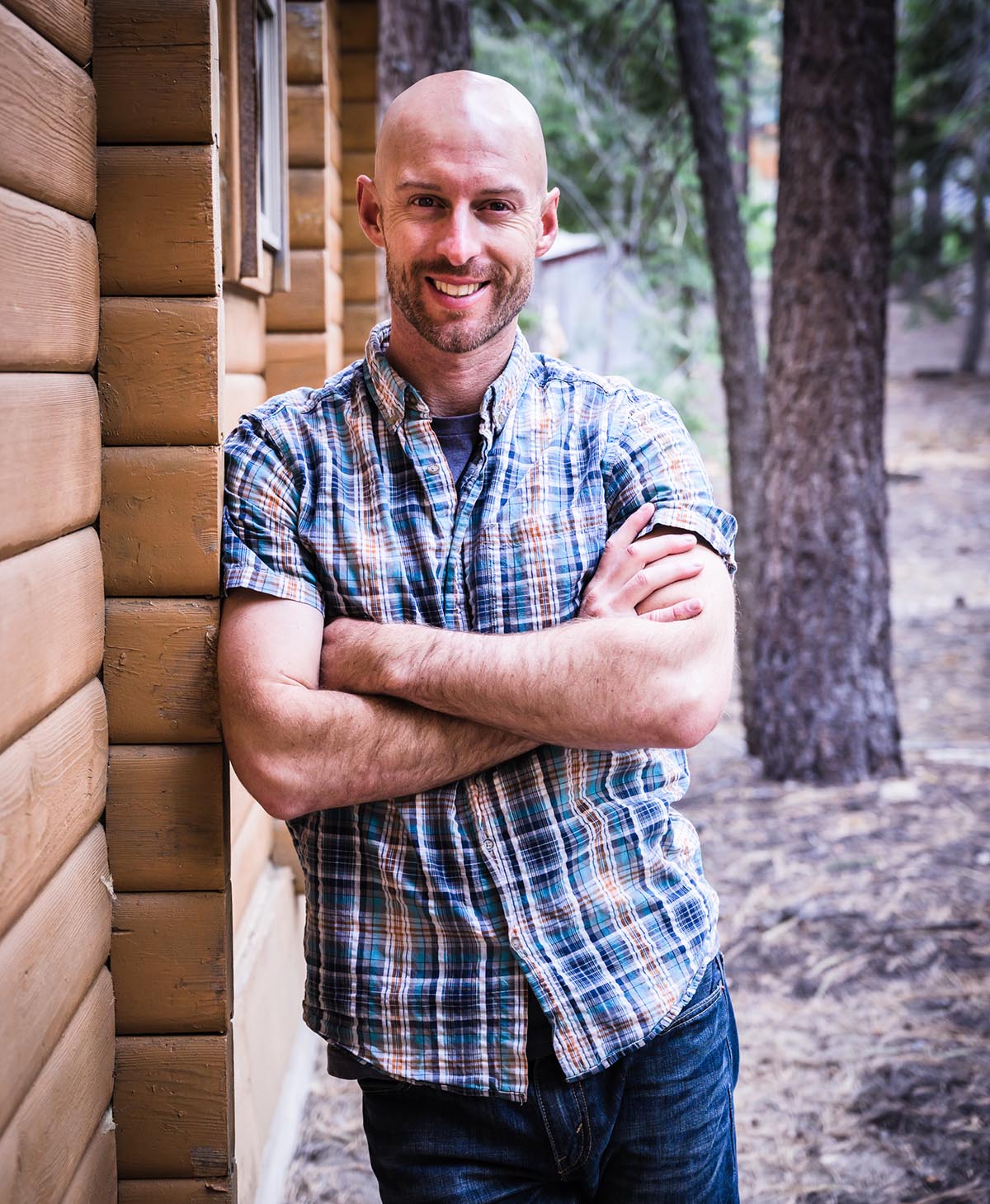
Joshua Cripps is a renowned landscape photographer who has garnered worldwide acclaim for his breathtaking images of our planet’s wild places. His photos have been published by the likes of National Geographic, NASA, CNN, BBC, and Nikon Global.
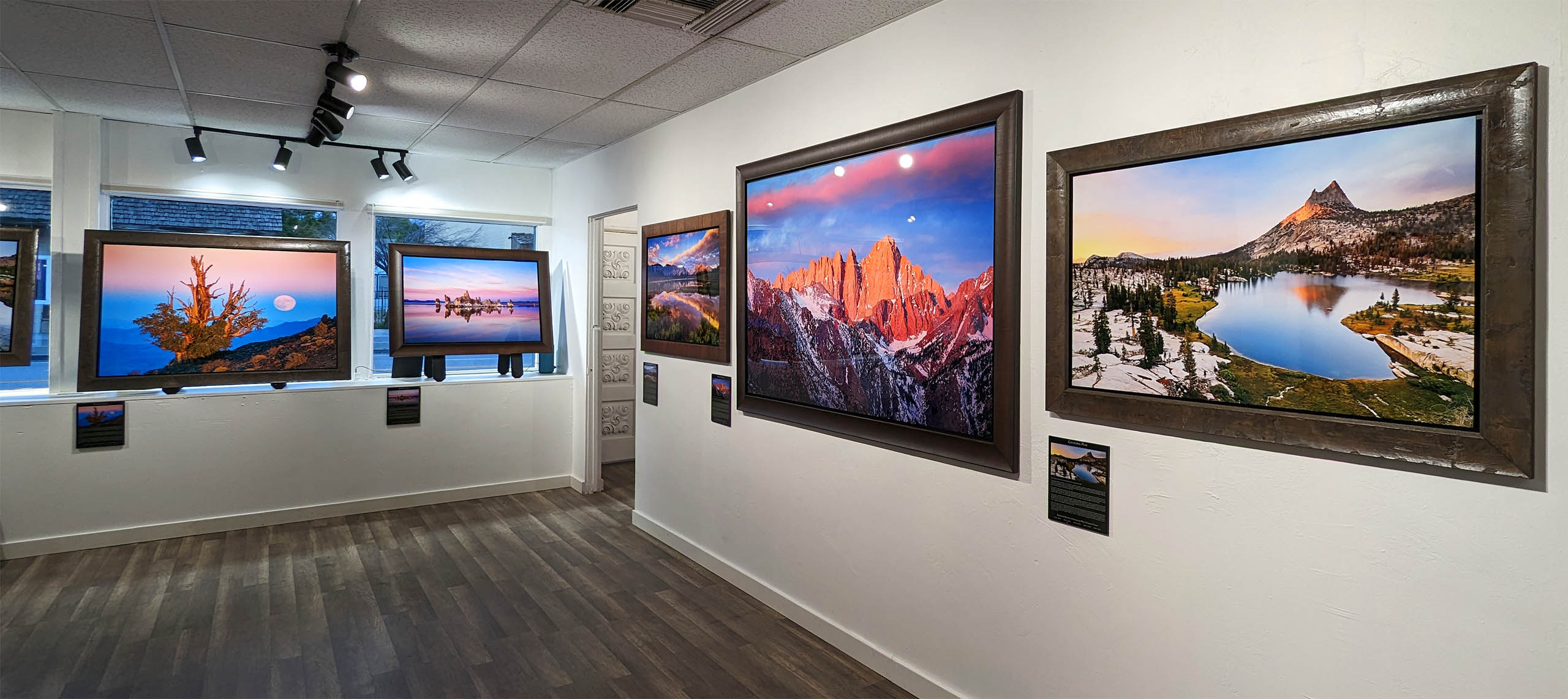
The Mount Whitney Gallery was founded in 2023 by Joshua Cripps as a way to share his passion stunning landscapes of the Sierra Nevada and beyond.
Set at the foot of the breathtaking Sierra with a view of the range’s highest peaks, the gallery features large format, museum-caliber fine art prints of Josh’s signature photographs.
Course Login | Results Disclaimer | Terms and Conditions | Privacy Policy
© Copyright – Joshua Cripps Photography